Arden Site Alerts for builders
Register the land you want in our 8 council areas. Sites are screened against your brief and paid members get matches first, each with a one-page site pack.
8 councilspublic data, sourcedchecked by handmax 3 paid builders / area
Ask about Site Alerts · £29/month
By ordering you agree to our builder terms. VAT not charged.
Register a free brief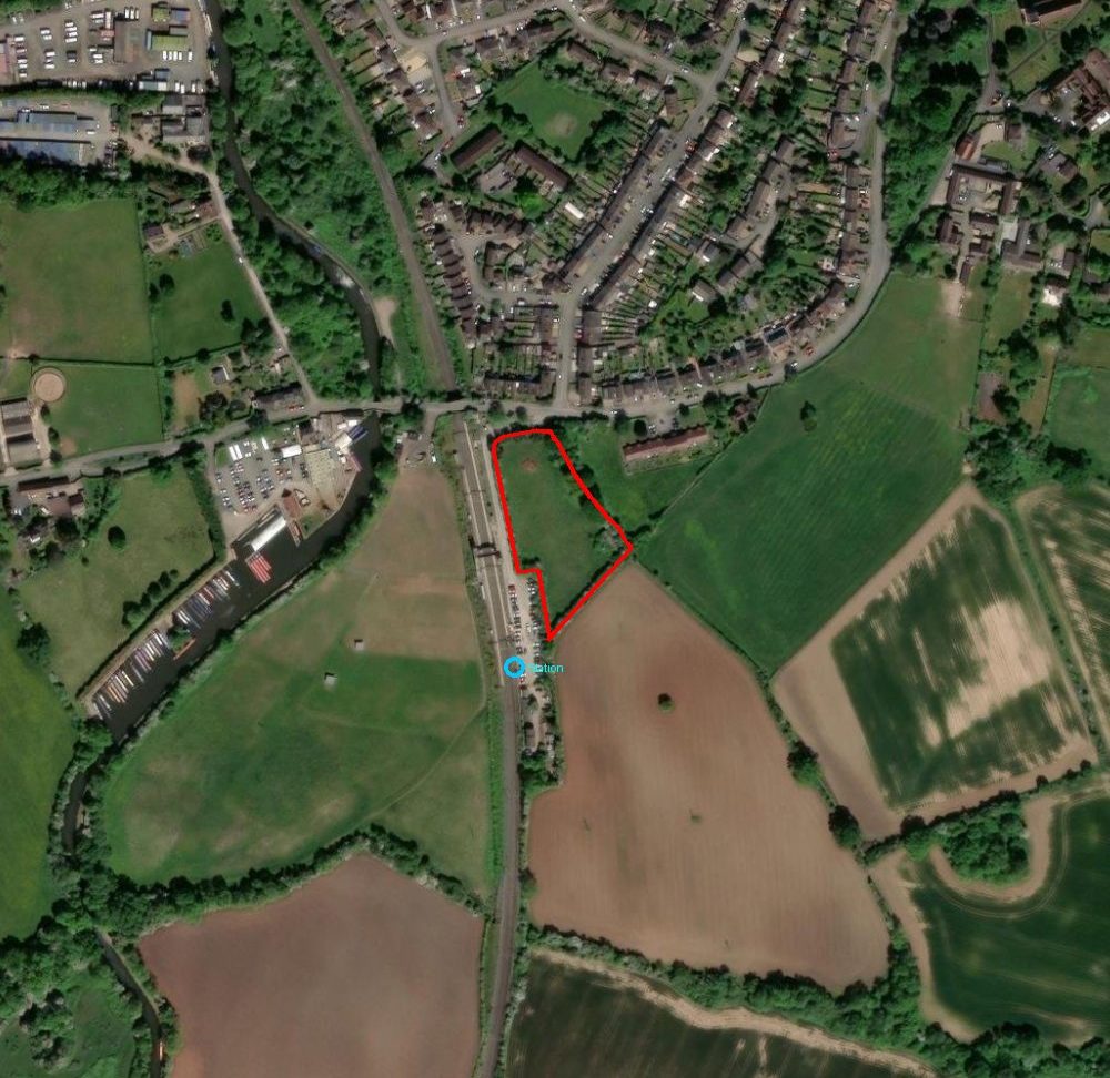
What goes into every alert
Each layer names its public source, so you can check every finding.
Plot boundary
Title outline and area, measured from the published polygon.
HM Land Registry INSPIREGreen Belt
Share of the plot inside the Green Belt, plus our council parcel score where we hold one.
planning.data.gov.ukFlood zones 2 & 3
Share of the plot in flood zone 2 or 3.
Environment Agency via planning.data.gov.ukPlanning history
Past applications and decisions on the plot.
Council planning registerLocal plan allocations
Whether the plot is in or next to a draft or adopted allocation.
Council local planCall for sites
Nearby land already put forward by owners or promoters.
Council call-for-sites / site submissionsConservation & listed
Conservation areas and listed buildings on or near the plot.
planning.data.gov.uk / Historic EnglandNearby approvals
Recent permissions close by, as a guide to what the council accepts.
Council planning registerFrom brief to alert
Register a brief
Councils, plot size or homes, budget and constraints.
Weekly watch
New plots, planning decisions, garage sites and auction lots in your areas.
Screen
Fixed filters for Green Belt, flood risk, size and promoter claims.
Alert + site pack
Paid members first, with a site pack (up to 5 a month).
Pass / fail before it reaches you
Our screen looks for plots at least 50% in the Green Belt (grey belt candidates).≥50% · pass
Less than 20% of the plot in flood zones 2 or 3.<20% · pass
Measured from the INSPIRE polygon.0.67 ha
Distance measured on the map.~100 m
Drawn from the council register in a live pack.not in sample
Checked against allocations and site submissions.promoted · fail
Sample site shown. A plot that fails the unclaimed check is never sent as an opportunity.
What an alert looks like
SAMPLEBromsgrove0.67 ha
Land south of Station Road, Alvechurch
Matched brief filters: size, station access, flood screen. Already promoted, so shown for illustration only.
flood <20%≥50% GBALV01 adj.history: n/a
Included with each match
Bromsgrove · sample pack
| Plot ID | INSPIRE 23481592 title not bought |
| Area | 0.67 ha1.66 ac |
| Access / transport | Next to the station car park. ~100 m to station |
| Green Belt | ≥50% Green Belt Council parcel score: not available |
| Flood zone 2/3 | <20% · passed screen |
| Local plan | Inside or next to draft allocation ALV01 (up to 400 homes, promoted by Catesby and Bloor) |
| Call for sites | Submission 146 adjoins (rear of Almshouses, Station Rd, 0.39 ha) |
| Planning history | not available in sample |
| Our view | Already promoted · not available |
Values from our sample pack. Sources: planning.data.gov.uk, Bromsgrove District Council settlement summary and site submissions, HM Land Registry INSPIRE. Open the full sample pack (PDF).
Plans
Register a brief
Free
- Register the land types, sizes, homes and councils you want.
- Matched sites sent to you by email when they come up.
Site Alerts
£29/month
Month to month.
- Early alerts on matching sites before they go to the free list.
- A one-page site pack for each match (up to 5 a month): satellite map, Green Belt score, planning history, flood zone and nearby approvals.
- A weekly planning watch for your chosen councils and site sizes.
- Garage site and auction alerts across the areas you choose.
- Up to 5 site packs a month per subscriber.
- Limited places: at most 3 paid builders per council area. When an area is full, you can join its waiting list.
By ordering you agree to our builder terms. VAT not charged.
Areas covered
Solihull, Warwick, Stratford-on-Avon, Bromsgrove, North Warwickshire, Lichfield, Rugby and Nuneaton & Bedworth, plus other West Midlands areas on request.
How site details are shared
A subscription pays for alerts and research, not for access to a landowner. Full site details and owner introductions are shared only under a signed introducer and non-circumvention agreement. Introducer fees are always disclosed to the landowner.
Good to know
- Auction watch: land lots in your areas checked for Green Belt, flood and planning before the sale. Included in Site Alerts.
- We reply to every brief and question within 1 working day.
- See a sample site pack (a real site already with a promoter, labelled as a sample).
- Month to month: cancel by email any time, with no auto-renew surprises. No annual contract.
- Your brief stays private. Owners only learn who you are when you choose to go ahead.
- Every site pack names its public sources, so you can check each finding.
- Need sites now? A one-off land search is £199, credited against the finder’s fee if you buy.
- Finder’s fee if you buy a plot we introduced: 2% of the purchase price, minimum £1,500, paid on completion and disclosed to the landowner. It also applies if you secure the plot by option or conditional contract, payable when that agreement is signed.
Please note: site packs are compiled from public sources and are general information only, not legal, planning or valuation advice. Always make your own checks before acting.
Questions? Email [email protected].